Flows
The Main Tuolumne is a dam controlled river with managed water releases throughout the spring and summer. The designated “Wild and Scenic” section of the Tuolumne begins northeast of the town of Groveland. Here you will find the spectacular whitewater runs of this protected river canyon. Though tightly regulated by the National Park Service, this popular section of the “T” is highly sought after for rafting and kayaking.
Tuolumne River Flow Graph
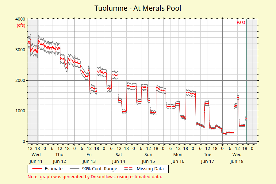
Dreamflows – Tuolumne River Flows
Flow Level Descriptions
- 900 – 1400 CFS = Low flows. Typical summer releases are perfect for kayaking and paddle rafting. Sometimes larger, heavier gear boats have a challenging time getting through more technical rapids at these flows.
- 1400 – 2500 CFS = Medium flows. Great for aggressive first timers and experienced rafters. Plenty of Class III & IV whitewater.
- 2500 – 4000 CFS = Medium-high flows. Great for experienced rafters and a few aggressive first timers. Plenty of Class III & IV+ whitewater.
- 4000 – 8000 CFS = High flows. Challenging Class IV+ whitewater, exciting for experienced rafters. Big waves and swift moving water.
- Above 8000 CFS = Extreme high flows. Fast moving water, with powerful waves and long rapids. Experience is highly recommended. Trips at these levels are best for very aggressive people who are not afraid of falling into a very fast river with long rapids.
CFS = Cubic Feet per Second
Insider Tip: Get Started Early
Make sure to get started early because water shuts off from Holm Powerhouse at 11am. If you are doing a trip on Cherry Creek, prepare for an early morning! Also, check the water releases because Sundays are often “dry” days.
Tuolumne Watershed
 The Tuolumne is one of the major rivers flowing west from the Sierra Nevada mountains in California. Originating in one of Yosemite National Park’s ice-age carved valleys, the canyon now fosters a perfect environment for whitewater enthusiasts.
The headwaters of the Tuolumne begin 13,000 feet above sea level at Mount Lyell. The river snakes its way to the sea by curving east to west, downstream until it connects with the San Joaquin River and eventually drains into the Pacific.
Flowing through what is called the Grand Canyon of the Tuolumne, the steep, V-shaped canyon walls hold flora distinctly characteristic of the coniferous forests of the foothills. The river canyon is blanketed with chaparral, manzanita, scrub brush, and oaks. Oddly enough the river canyon appears to be more lush than the Yosemite Canyon rim above even though the canyon floor typically receives less rainfall than the rim each year.
Just below O’Shaunessy Dam and the Hetch Hetchy Reservoir, the Tuolumne begins to flow through Stanislaus National Forest and is joined by the Upper Tuolumne, better known as Cherry Creek. Clavey river joins the Tuolumne mid-way through the descent. At the confluence of the two rivers, the thrilling class IV+ rapid known as Clavey Falls, provides a landmark to rafters and kayakers heading downstream. If the chance to hike along the Clavey and swim in its warm, natural granite pools arises don’t miss this highly recommended experience.